
Drone Drainage Design in Waxhaw, Weddington & South Charlotte
- carolinaterrain

- Jul 11, 2025
- 4 min read

Seeing Drainage Problems From the Sky: The Carolina Terrain Approach
In the clay-heavy soils of Waxhaw and surrounding Union County, poor drainage, compacted lawns, and standing water are common problems. But many of these issues are hard to diagnose from the ground. That’s why Carolina Terrain uses drone-based surveying to see what others miss. Drone-based surveying methods have been proven more efficient and accurate than traditional surveying for environmental and grading applications (Remote Sensing Journal, 2020).
Drone imagery helps us identify slope failures, stormwater collection zones, and runoff channels. We then design engineered drainage solutions, paired with soil remediation and erosion control strategies, using precise data collected from the air.
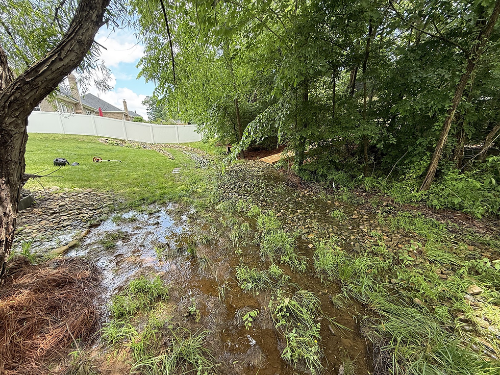
Case in Point: Ryan M. – Harpers Grove, Waxhaw, NC
At Ryan’s property in Waxhaw, drone imagery made it clear where water was pooling and how it was flowing through the yard — especially in the rear lawn and along the slope edges.

Note the visible runoff channeling and pooling patterns revealed only through aerial assessment.
From Drone to Design: How We Plan Smart Drainage Systems
Using Ryan M.’s project as an example, here’s how we use drones at every stage of the project lifecycle:
1. Site Survey & Topographic Data
We conducted a drone-based aerial grading inspection to gather elevation profiles and identify all contributing drainage areas. The site generated over 350 GPM of stormwater during a 10-year, 30-minute rain event — something not obvious from ground level.
Drone-based surveying methods have been proven more efficient and accurate than traditional surveying for environmental and grading applications (Remote Sensing Journal, 2020).
2. Quoting & Material Takeoff
Using scaled drone imagery, we accurately calculated:
140 linear feet of 6-inch French drain trenching
Over 260 linear feet of solid conveyance pipe
Placement of multiple 9" and 12" NDS catch basins
Pop-up emitter discharge points in both front and rear yards
Mulch and pine straw square footage for erosion zones
This process allowed us to provide a precise quote of $17,976.39, with full transparency and line-item clarity.
3. 2D Design Overlays for Clarity
The drone photo was overlaid with a custom 2D drainage design, which was used to explain the full scope to the homeowner, document HOA compliance, and guide the installation team.

This design included vertical mulching, soil remediation zones, plantings, and all drainage infrastructure, scaled to fit the property precisely.
4. Soil Remediation with USDA-Backed Techniques
Ryan’s rear lawn suffered from extreme clay compaction, a common issue in the Piedmont region. We implemented deep mechanical conditioning, compost-based topdressing, and 190 vertical mulch columns to break up subsurface density and improve infiltration. These methods align with USDA NRCS guidance for reducing compaction and improving subsoil conditions (USDA).
5. Erosion Control Backed by NC State Extension
We stabilized the rear slope and side yard using long-needle pine straw and native plants including Ajuga and Pink Muhly Grass. These were installed in a staggered pattern to form a natural buffer between turf and woodline. This approach reflects research-backed recommendations from NC State Extension on vegetative erosion control.
6. Drainage System Engineered to EPA Standards
The complete drainage system was designed using data collected on runoff volume, slope, and catchment area. Components included:
NDS 6" dual-wall N-12 pipe
Catch basins with Downspout Defenders
French drains with #67 gravel and geotextile fabric
Pop-up emitters for controlled discharge
This aligns with best practices from the EPA Green Infrastructure Program, which promotes stormwater control through engineered design and sustainable materials.
High-Performance Solutions Backed by Aerial Data
The project for Ryan M. included:
Full rear yard turf remediation using deep soil conditioning and compost-based topdressing
190 vertical mulch columns (gravel + compost) to relieve clay compaction
Strategic erosion control with pine straw and native plantings
Complete drainage system design with NDS dual-wall pipe, catch basins, and pop-up emitters
Optional upgrades including front yard core aeration, seeding, and mulch installation
All of this was planned and scoped based on aerial topographic survey data, ensuring the system is built to handle real-world storm events and site flow volumes.
Drone-Supported Execution for Accuracy and Speed
Once installation began, our crew used the drone design overlay to:
Lay pipe and drainage components exactly per plan
Minimize yard disruption and rework
Complete the full scope efficiently and cleanly
This drone-to-field workflow ensures every project meets engineering standards and long-term performance goals.
Serving Greater Waxhaw with Drone-Powered Drainage Design
Carolina Terrain provides drone drainage surveys, soil testing, and engineered design services throughout the South Charlotte region, including:
Waxhaw
Weddington
Marvin
Wesley Chapel
Matthews
Indian Trail
Mineral Springs
Monroe
Stallings
South Charlotte (Ballantyne, Piper Glen, Providence Plantation)
If you’re searching for a drainage contractor using drones in Union County, we are the region’s leader in aerial-based design and installation.
Schedule a Drone Drainage Assessment Today
If your lawn floods, has standing water after storms, or needs a fresh start, let us evaluate it with drone precision. Our turnkey designs fix the root problems — not just the symptoms.
Call Carolina Terrain at 980-280-7638 or request a property assessment to schedule your drone-powered drainage consultation.
Sources
drone drainage survey Waxhaw NC
drone property assessment Weddington NC
aerial grading inspection Marvin NC
topographic survey drone Union County NC
French drain installation Waxhaw NC
drainage contractor using drone Charlotte South
soil remediation Waxhaw NC
vertical mulching Union County NC
erosion control with drone survey Weddington
Carolina Terrain drone drainage design


Really impressed with how drones are transforming drainage design — it’s fascinating to see data-driven planning replacing guesswork. We’ve also shared some insights on sustainable landscaping practices that complement this approach